How Deforestation has Triggered the Chain Reaction Resulting in the Rising Water Level of Kenya’s Rift Valley Lakes

A local fisherman paddles a traditional raft made from reeds past one of the submerged buildings of the Soi Lodge on the shores of Lake Baringo, where rising water levels have seen the lake surface area expand to occupy elevated ground surrounding it's shores displacing entire villages and inundating farmland and crops as well as building and infrastructure, near Marigat, Baringo county on the Kenyan Rift Valley, on October 6, 2020. TONY KARUMBA / AFP / Getty Images
Rising water levels evoke images of the sea level rise that is because of melting polar ice caps that are menacing low-lying coastlines. However, the phenomenon affecting the East African Rift Valley, while also partially attributable to climate change, is seemingly a consequence of a complex combination of anthropogenic, ecological, and geological factors – another stark reminder of how human activity has inadvertently upset the delicate balance of natural systems.
Kenya’s Great Rift Valley Lake System[1] designated Wetlands of International Importance (Ramsar Sites) [2] includes, among others, Lakes Naivasha, Nakuru, Bogoria and Baringo [3] [4]. Over the last decade the lakes have swollen to record levels displacing thousands of people[5] from their homes and farmlands, submerging schools, health facilities and social amenities, rendering public infrastructure like roads impassable, and stranding wildlife.
Several hypotheses have been advanced to explain the hydrological imbalance being observed in these lakes. On the one hand, the Regional Centre for Mapping of Resources for Development (RCMRD)[6] undertook to establish whether there exists any correlation between the increasing lake surface area and rainfall patterns within the lake catchment area by using geospatial and remote sensing technologies to extract time series of surface area of the lakes based on analysis of satellite images (Landsat 8) from May 2013 to October 2020, and overlaying the information with satellite derived lake catchment rainfall data (CHIRPS) over a similar time period.
[1]http://www.ku.ac.ke/schools/environmental/images/stories/research/Geospatial_Extent_20011-2013.pdf
[2]https://rsis.ramsar.org/sites/default/files/rsiswp_search/exports/Ramsar-Sites-annotated-summary-Kenya.pdf?1637510501
[3]https://whc.unesco.org/en/list/1060/multiple=1&unique_number=1749
[4] https://naturalworldheritagesites.org/sites/kenya-lake-system-in-the-great-rift-valley/
[5] https://www.ecowatch.com/kenya-rift-valley-flooding-2649082228.html?rebelltitem=1#rebelltitem1
[6] https://rcmrd.org/the-rising-water-level-and-expansion-of-the-rift-valley-lakes-from-space
Lake Naivasha is a freshwater lake located at the highest elevation of the Kenyan Rift valley at 1,884m above sea level with a documented surface area of about 139 km2 and a rainfall catchment area of about 2,380km2. Between 2018 and 2019, the lake level rose and increased in surface area by about 10% covering about 155km2. This coincided with the increase in lake catchment area rainfall of 65% and 21% above normal in 2018 and 2019 respectively.
Lake Nakuru is an alkaline lake located at an elevation of 1,754 m above sea level with mean surface area of about 47km2 and rainfall catchment area of about 1,760km2. From satellite image analysis, the lake surface area increased by about 15% between 2018 and 2019 to about 64km2. Like Lake Naivasha, the increase coincided with a significant increase in rainfall over the catchment area of 50% and 20% above normal in 2018 and 2019 respectively.
Lake Baringo, a second freshwater lake with an elevation of 970m above sea level, drains a catchment area of about 6,820 km2 with annual rainfall ranging from about 600mm to 1500mm. From the satellite image analysis, the lake surface extent has increased by about 6% in 2018 and 2019.
Lake Bogoria, the saline alkaline lake that lies just south of Lake Baringo, has a surface area of about 39km2 at an altitude of about 960m above sea level. The lake surface area has increased minimally northward towards Lake Baringo by about 5% from the long-term mean with shoreline changes in some sections of the lake that are remarkably observable from satellite imagery. Rainfall over the catchment has significantly increased by 50% and 18% above normal in 2018 and 2019 respectively.

Figure 1: East African Rift System, including lakes in Kenya depicted as red points. From North to South: (a) Lake Baringo, (b) Bogoria, (c) Solai, (d) Nakuru, (e) Elementaita, and (f) Naivasha. (Data sources for mapping: Esri, Garmin, GEBCO, NOAA, NGDC, hydro1k, naturalearthdata.com)
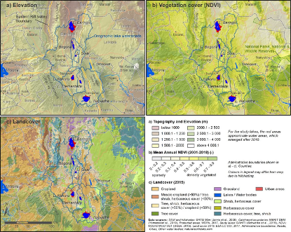
Figure 3: Study lakes and orographic catchment boundaries. Elevation and topography (a), the mean annual MODIS NDVI for the period 2001-2018 as a proxy for vegetation cover (b), and a slightly generalized land cover (c) are plotted to characterize spatial properties of the study region. For the study lakes, the red areas approximate water areas, which emerged after 2010.

Figure 2: Water occurrence from 1984 to 2020 for the investigated lakes with data, emphasizing the variability of the surface area for the respective lakes in the given time period. Data based on Schwatke et al. (2015).
Figure 3 shows the spatial characteristics of the Central Rift Valley and gives an overview of the landscape in which the lakes are located.
· Panel (a) depicts the topography and elevation, including the orographic (mountainous) catchment areas, highlighting the fact that the lakes lie in closed basins, where the lake is the sink and where no surface outlets are present. The lakes are all located in the Rift Valley floor, encircled by high mountain ranges and escarpments. The lowest lake regarding lake level but also mean catchment elevation is Baringo in the North and the highest is Lake Naivasha in the South.
· Vegetation cover is indicated in panel (b) utilizing the mean annual NDVI[1]. Vegetation density closely follows elevation, with the higher areas and escarpments of the Aberdares Ranges east of Naivasha, the Mau Escarpment west of Nakuru or the mountain ranges around the Kerio Valley east of Bogoria and Baringo, showing higher vegetation cover.
· Landcover as depicted in panel (c) reveals a mix of shrub, trees and herbaceous cover are characteristic for the Rift Valley floor. Higher elevation areas show a landcover dominated by tree and herbaceous cover. East of the study area, shrub and herbaceous cover dominate the Laikipia plains.
Despite apparent correlations drawn between the climate-change-associated increased rainfall over the lake catchment areas, and the rising lake water levels, the underlying causal factors remain inconclusive. The role of geological activities, lake catchment land use change, land degradation and sediment yield into the lakes from the lakes’ water catchment areas are key to the understanding the phenomenon.
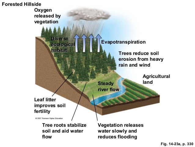
One study[2] observes that the affected Rift Valley lakes - all of which lie in closed basins without surface outlets - are in a highly geologically active zone in the earth’s crust and suggests that recent movement of tectonic plates in the region could have decreased underground permeability, thereby decreasing subterranean outflow or seepage. This process has been described as hasty hydrogeological instationarity and has been rationalised by the continued geothermal and volcanic activity witnessed within the entire region. Anthropogenic influences leading to land-use and land-cover (LULC) change and the degradation of lake water catchment areas through soil erosion have also been advanced as an important contributor to the phenomenon. It is suggested that underground lake water inlets and outlets are potentially clogged due to higher sediment loads from degraded lake water catchment area. Moreover, higher sedimentation impact lake volumes, rising the lake floors, and causing the lake water levels to rises. Hydrologically, land-use and land-cover (LULC) changes, primarily deforestation to make way for agriculture, have led to accelerated rainwater surface runoff and less infiltration into soil. This in turn affects the overall hydrological systems in the longer-term due to decreased evapotranspiration[3] necessary for cloud formation and precipitation.
Kiage and Douglas (2020) confirm that the recent drastic hydrologic changes to Kenya’s Rift Valley Lakes have multiple natural and anthropogenic causations including land cover and land use change, increase in rainfall, and possible change in geogenic water input due to tectonic activity[4]. This is hypothetically supported by analogous international analysis[5] that has observed that flood frequency is negatively correlated with the amount of remaining natural forest within countries and positively correlated with natural forest area loss. Loss of forests increase or exacerbate the number of flood-related disasters as illustrated in Figure 4 below.
[1] The normalised difference vegetation index (NDVI) is a simple graphical indicator that can be used to analyze remote sensing measurements, often from a space platform, assessing whether or not the target being observed contains live green vegetation (https://en.wikipedia.org/wiki/Normalized_difference_vegetation_index )
[2] https://www.sciencedirect.com/science/article/pii/S2214581821000860#bib0265
[3] https://www.sciencedirect.com/science/article/abs/pii/S0022169403005171
[4] https://pubmed.ncbi.nlm.nih.gov/31884292/
[5] https://www.cifor.org/knowledge/publication/3156/


Figure 4: Images Source: http://image.slidesharecdn.com/waterbook-140126082549-phpapp02/95/water-64-638.jpg?cb=1390724857, https://image.slidesharecdn.com/waterbook-140126082549-phpapp02/95/water-65-638.jpg?cb=1390724857
When we contemplate the consequences of deforestation, we imagine degraded habitats stripped of biodiversity and exposed to soil erosion. And then when we consider the adverse weather conditions of associated climate change, we imagine these deforested ecosystems stricken by drought and tittering on the brink of desertification.
These are the scenarios that dominate common discourse - scenarios that portray natural systems as single-dimensional step-by-step mechanisms that can be modeled with a certain level of predictability. That is, until something completely unpredictable happens such as deforestation triggering a chain reaction resulting in the significant rising water levels of the lakes in Kenya’s Rift Valley.